#AI reveals secret roads endangering the world’s rainforests
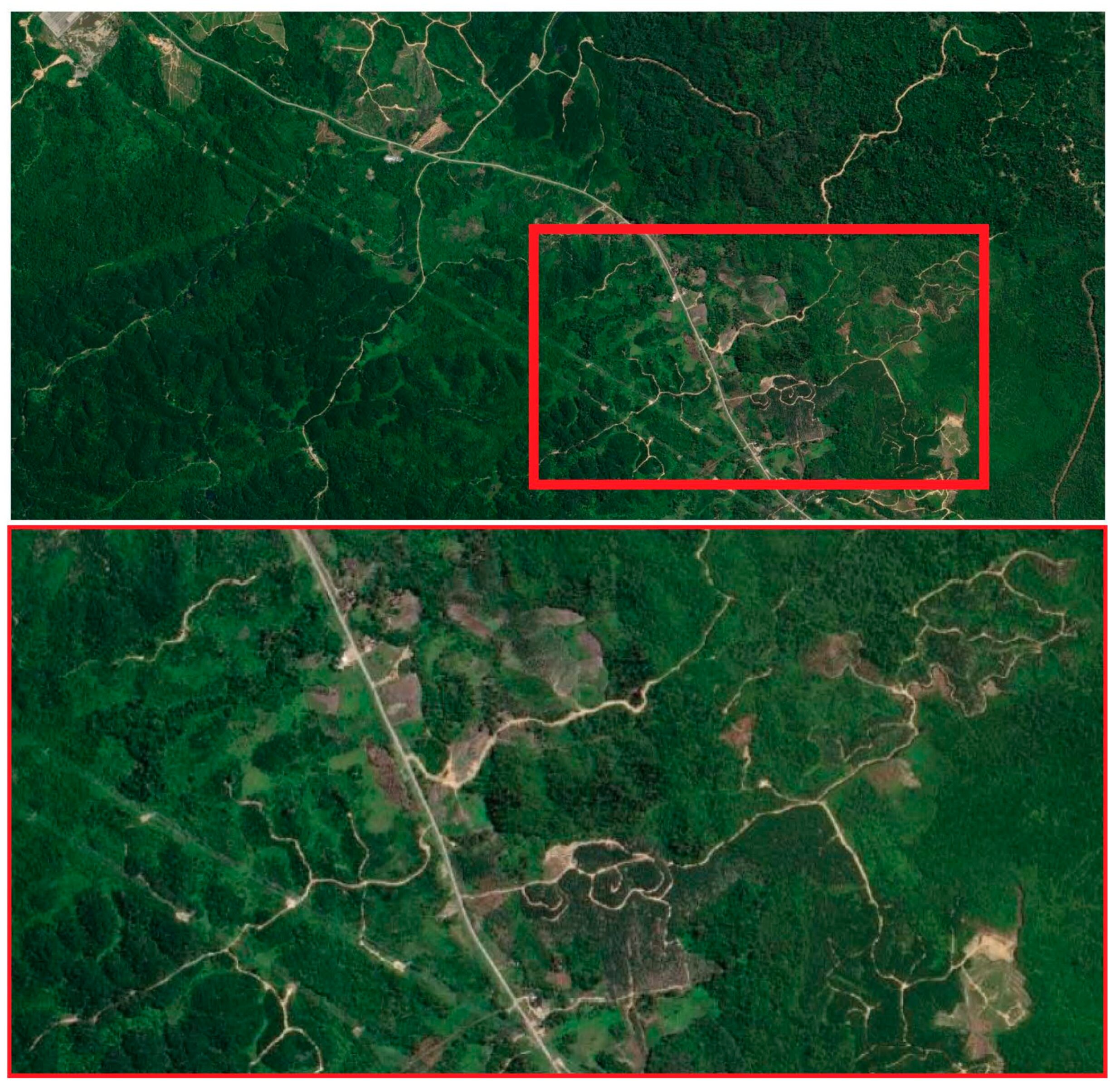
 and for a smaller inset area (bottom) featuring clearly discernible land covers and road infrastructure. Credit: Remote Sensing (2024). DOI: 10.3390/rs16050839")
Satellite images analyzed by AI are emerging as a new tool in finding unmapped roads that bring environmental destruction to wilderness areas.
James Cook University’s Distinguished Professor Bill Laurance was co-author of a study analyzing the reliability of an automated approach to large-scale road mapping, using convolutional neural networks trained on road data, using satellite images.
He said the Earth is experiencing an unprecedented wave of road building, with some 25 million kilometers of new paved roads expected by mid-century.
“Roughly 90% of all road construction is occurring in developing nations including many tropical and subtropical regions of exceptional biodiversity.
“By sharply increasing access to formerly remote natural areas, poorly regulated road development triggers dramatic increases in environmental disruption due to activities such as logging, mining and land clearing,” said Professor Laurance.
He said many roads in such regions, both legal and illegal, are unmapped, with road-mapping studies in the Brazilian Amazon, Asia-Pacific and elsewhere regularly finding up to 13 times more road length than reported in government or road databases.
“Traditionally, road mapping meant tracing road features by hand, using satellite imagery. This is incredibly slow, making it almost impossible to stay on top of the global road tsunami,” said Professor Laurance.
The researchers trained three machine-learning models to automatically map road features from high-resolution satellite imagery covering rural, generally remote and often forested areas of Papua New Guinea, Indonesia and Malaysia.
“This study shows the remarkable potential of AI for large-scale tasks like global road-mapping. We’re not there yet, but we’re making good progress,” said Professor Laurance.
“Proliferating roads are probably the most important direct threat to tropical forests globally. In a few more years, AI might give us the means to map and monitor roads across the world’s most environmentally critical areas.”
The work is published in the journal Remote Sensing.
Sean Sloan et al, Mapping Remote Roads Using Artificial Intelligence and Satellite Imagery, Remote Sensing (2024). DOI: 10.3390/rs16050839
Citation:
AI reveals secret roads endangering the world’s rainforests (2024, February 29)
retrieved 29 February 2024
from https://phys.org/news/2024-02-ai-reveals-secret-roads-endangering.html
This document is subject to copyright. Apart from any fair dealing for the purpose of private study or research, no
part may be reproduced without the written permission. The content is provided for information purposes only.
If you liked the article, do not forget to share it with your friends. Follow us on Google News too, click on the star and choose us from your favorites.
If you want to read more Like this articles, you can visit our Science category.