#High wave flooding in West Maui predicted through new online tool
“#High wave flooding in West Maui predicted through new online tool”

A high-resolution, real-time wave run-up forecast tool, able to predict coastal flooding up to six days in advance, has been developed for the West Maui shoreline. The Pacific Islands Ocean Observing System (PacIOOS) created the novel online tool , which will increase preparedness and coastal resiliency for West Maui community members, property owners, businesses, as well as state and county officials.
West Maui’s shoreline has experienced an increase in wave plus tide-driven flooding in recent years, and these events are expected to grow in numbers and duration due to sea-level rise and changing wave energies. Chronic coastal erosion is leading to severe damage of properties and the associated land-based sediment impairs the nearshore water quality. Wave overtopping and flooding also pose a major safety concern to infrastructure, in particular to Honoapiʻilani Highway, the only access point to West Maui.
“West Maui has an extremely complex nearshore environment. Waves, currents and water levels are influenced by the highly variable ocean floor, which ranges from deep ocean channels to shallow plateaus. This dynamic environment can lead to significant, yet unexpected, wave run-up and coastal flooding,” said co-investigator Douglas Luther, Department of Oceanography at University of Hawaiʻi Mānoa’s School of Ocean and Earth Science and Technology (SOEST). “The areas of impact and the severity of impact are not only a function of wave height, wave direction and tides. Our modeling efforts capture all the physical drivers that contribute to wave run-up, allowing us to shed light on this intricate interplay.”

Six-day outlook
To account for the complexity and differences along the West Maui shoreline, the team divided the shoreline into 12 regions. Each region, from Pāpalaua Wayside Park in the south to Lipoa Point in the north, has its own unique forecast that provides a six-day outlook of potential wave run-up.
With the dedicated support of volunteer citizen scientists, photo documentation has been collected in recent years to capture wave run-up and flooding events at various sites along the West Maui coastline. This database of photos is a key element for the project to better understand on-the-ground vulnerabilities. It also allowed the project team to establish region-specific thresholds, distinguishing between “light impacts,” “hazardous impacts,” and “critical impacts.”
Tara Owens, UH Sea Grant College Program (Hawaiʻi Sea Grant) coastal specialist and co-investigator for this project, said, “With the concentration of impacts in West Maui already, I am really pleased that the community now has a tool at hand that gives advance notice of potential flooding and run-up impacts. Knowing what to expect now and in the future will allow us to be proactive in our approaches to prepare and mitigate.”
-
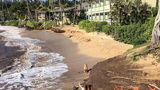
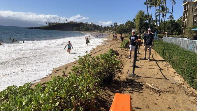
With sea level rise, wave run-up and worsening coastal erosion cause impacts to shoreline vegetation, coastal properties, and nearshore water quality at Nāpili Bay. Credit: Brenda Jarmakani
-
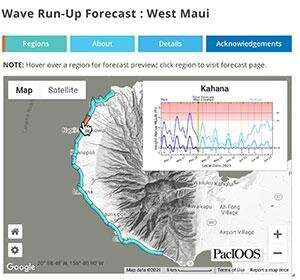
The new, high-resolution wave run-up forecast for West Maui predicts high wave flooding for the upcoming 6 days. Credit: University of Hawaii at Manoa
The forecast will continue to evolve over time as more wave run-up events occur and additional photo documentation becomes available. Participants can get involved and help improve the forecast by collecting photo documentation of wave run-up events along the West Maui coastline online.
The forecast was developed by PacIOOS in collaboration with SOEST, Hawaiʻi Sea Grant, the County of Maui and the State of Hawaiʻi Department of Land and Natural Resources. The project was made possible through funding from NOAA’s Regional Coastal Resilience Grants Program. Additional funding was provided by the Joint Institute for Marine and Atmospheric Research, Hawai’i Sea Grant and PacIOOS along with in-kind support from Ultimate Whale Watch, Sands of Kahana of Soleil Management and UH Maui College.
New coastal overtopping forecast made available to the public
The public is invited to join on Tuesday, June 8, 4–5 p.m. for an informational presentation via Zoom to introduce the new tool and answer questions. Register here to receive log-in information. us02web.zoom.us/meeting/regist … -LBLez_CALBk1SEjCWCu
Citation:
High wave flooding in West Maui predicted through new online tool (2021, June 4)
retrieved 4 June 2021
from https://phys.org/news/2021-06-high-west-maui-online-tool.html
This document is subject to copyright. Apart from any fair dealing for the purpose of private study or research, no
part may be reproduced without the written permission. The content is provided for information purposes only.
If you liked the article, do not forget to share it with your friends. Follow us on Google News too, click on the star and choose us from your favorites.
For forums sites go to Forum.BuradaBiliyorum.Com
If you want to read more Like this articles, you can visit our Science category.