#Powerful atmospheric river pummels Northwest with over 8 inches of rain, killing 1
CNN
—
At least one person is dead and over 10 million people are under flood alerts across the Pacific Northwest Tuesday as a strong atmospheric river pelts the region already soaked by previous atmospheric rivers with more heavy rainfall.
Emergency crews in Portland, Oregon, were unable to rescue a man swept away by a flooded creek on Monday. The man’s body was recovered from Johnson Creek later Monday afternoon, a Multnomah County Sheriff’s Office deputy told CNN.
Investigators are still trying to determine how the man ended up in the fast-moving water.
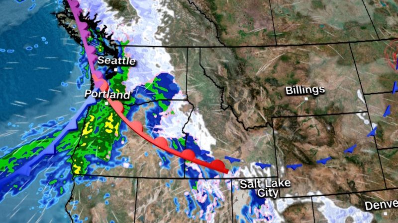
More than 8 inches of rain has already fallen in the region over the last 24 hours and rivers are rising into flood stage, with multiple rivers forecast to reach major flood levels over the next 24 hours.
In Washington, the Skagit and Snoqualmie rivers are of particular concern. Portions of both rivers surged to major flood stage by late Tuesday morning and are forecast to flood roads, farms and even some residential areas. Water levels on portions of the Skokomish River in western Washington climbed to moderate flood stage earlier Tuesday morning and the Grays River in southern Washington skyrocketed to major flood stage.
Floodwater forced dozens of roadways to close in Washington on Tuesday. At least one driver was rescued after driving their car into floodwaters on a Snohomish County road.
A landslide amid heavy rainfall brought all Amtrak service between Seattle and Portland, Oregon, to an abrupt halt Tuesday. Service between the two hubs is suspended until Thursday morning, according to Amtrak.
Additional heavy rainfall through Wednesday will only make matters worse in parts of Oregon’s Cascade mountains, southern Washington and far northwest California. A slight risk, or Level 2 of 4, of excessive rainfall is in place Tuesday with a marginal risk, or Level 1 of 4, on Wednesday, according to the Weather Prediction Center.
Flood watches stretch from coastal Oregon and Washington into northeastern Washington and northern Idaho. While most are set to expire by Wednesday evening, a few will last into Thursday.
Washington’s Olympic mountains could receive over a foot of rain, and the Cascades could see between 5 to 9 inches, the weather service said. Along the coast, residents can expect 3 to 5 inches and 1 to 3 inches in the interior lowlands.
Monday and Tuesday’s atmospheric river is already registering impressive totals: Olympic National Park in Washington recorded 8.67 inches in the last 24 hours with more rain to come.
For residents caught in flood conditions, the weather service recommends staying indoors or seeking higher ground if shelter isn’t available.
By late Thursday and Friday, storm activity is forecast to ramp down across much of the Northwest, but showers and some high-elevation snow remain possible.
But the break from soggy weather may be short-lived. Confidence is growing in yet another atmospheric river that could hit the region by the early weekend.
The exact strength and overall impact of this potential event should become clearer once this week’s atmospheric river comes to an end on Wednesday.
The sequence of back-to-back atmospheric rivers, called an AR family, began Saturday and did not leave much of a break period before Monday night’s system began. This lack of recovery time is a major factor in the increased risk of flooding.
Parts of Utah and Colorado received snowfall on Monday, bringing total snowfall throughout the atmospheric river events to several feet in some places, including 50 inches in Collins, Utah, and 49 inches in Colorado’s Rabbit Ears Pass.
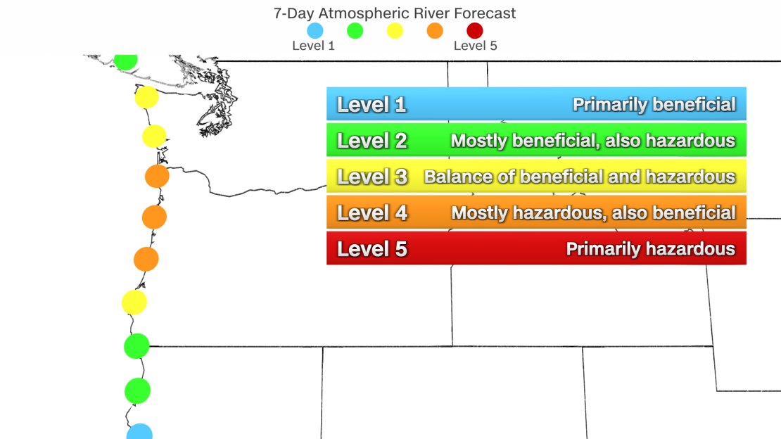
A Level 4 out of 5 atmospheric river event is forecast to hit roughly the entire coastline of Oregon this week. The severity of the atmospheric river reached a Level 5 out of 5 in the far northwestern part of the state Monday night into early Tuesday morning.
But this latest round of moisture also ushered in warmer temperatures, including a high temperature of 65 degrees in Portland, which ties with the city’s all-time high for the month of December last set in 1993.
These warm conditions have encouraged snowmelt across the Pacific Northwest and may lead to excessive runoff and rising creeks and streams.
Not all atmospheric river events are bad. In fact, AR event levels 1 and 2 are considered mostly beneficial rains and are much needed across the western US to build water supply levels. But AR event levels 4 and 5 are more hazardous than they are beneficial as the risk for flooding and travel dangers outweigh the benefits.
CNN’s Andy Rose, Sara Smart, Allison Chinchar and Sara Tonks contributed to this report.
If you liked the article, do not forget to share it with your friends. Follow us on Google News too, click on the star and choose us from your favorites.
For forums sites go to Forum.BuradaBiliyorum.Com
If you want to read more News articles, you can visit our News category.