#NASA imagery reveals Tropical Storm Chan-hom’s skewed structure
“#NASA imagery reveals Tropical Storm Chan-hom’s skewed structure”
. Credit: NASA Worldview, Earth Observing System Data and Information System (EOSDIS).")
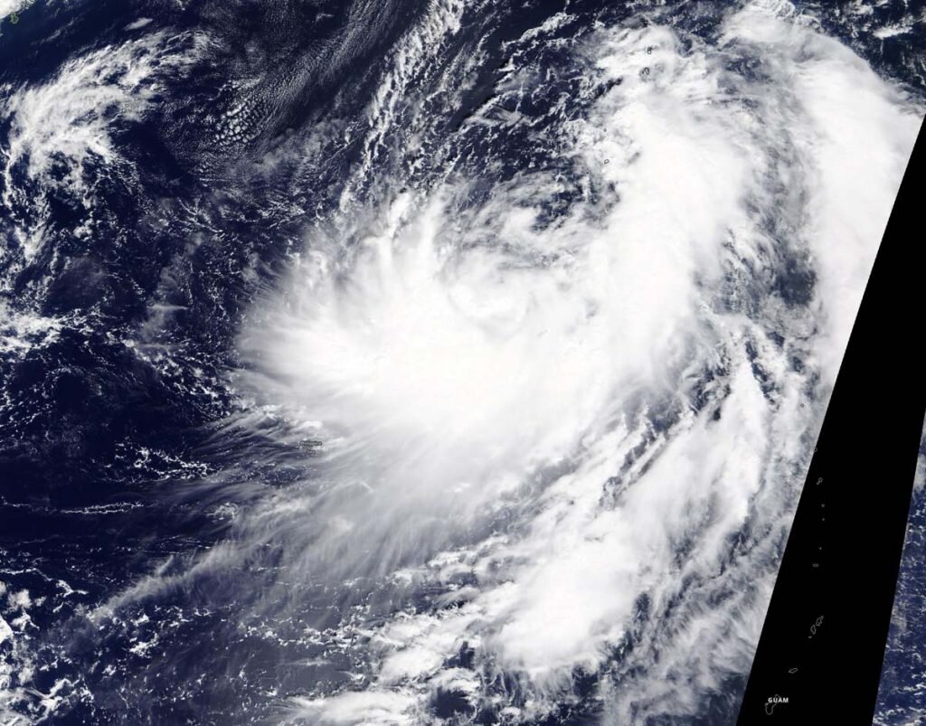
NASA’s Terra satellite obtained visible imagery of Tropical Storm Chan-hom as it continued moving though the Northwestern Pacific Ocean. The imagery revealed that the center of circulation was exposed and its strongest storms were south of the center.
Tropical Depression 16W formed on Oct. 4 and strengthened into a tropical storm on Oct 5. Once it reached tropical storm strength, it was re-named Chan-hom. Laos submitted the name Chan-hom to the World Meteorological Organization list. The name is a type of tree in Laos.
NASA satellite view: Chan-hom’s organization
The Moderate Resolution Imaging Spectroradiometer or MODIS instrument that flies aboard NASA’s Terra satellite captured a visible image of Tropical Storm Chan-hom on Oct. 5 that showed a couple of things were occurring in the storm. First, bands of thunderstorms were wrapping into a partially exposed low-level circulation center. Second, there was building convection and thunderstorms occurring over the southern quadrant of the storm, giving it an appearance of a backwards letter “C” on satellite imagery. The storm is expected to strengthen over the next three days and when it does, it will likely develop a more circular shape.
The satellite imagery was created using NASA’s Worldview product at NASA’s Goddard Space Flight Center in Greenbelt, Md.
Chan-hom’s status on Oct. 5
At 11 a.m. EDT (1500 UTC) on Oct. 5, Chan-hom was centered near latitude 23.0 degrees north and longitude 139.2 degrees east. That is about 738 miles south of Yokosuka, Japan. Chan-hom is moving north and has maximum sustained winds of 35 knots (40 mph/64 kph).
Chan-hom’s forecast
The Joint Typhoon Warning Center noted, “Chan-hom is forecast to track generally northwestward along the southwestern periphery of a sub-tropical ridge (elongated area of high pressure) over the next three days. During this time, the system will steadily intensify to a peak intensity of 85 knots (98 mph/157 kph) by three days largely due to the continued low vertical wind shear and warm sea surface temperatures.”
NASA finds Tropical Storm Dolphin going swimmingly
Citation:
NASA imagery reveals Tropical Storm Chan-hom’s skewed structure (2020, October 5)
retrieved 5 October 2020
from https://phys.org/news/2020-10-nasa-imagery-reveals-tropical-storm.html
This document is subject to copyright. Apart from any fair dealing for the purpose of private study or research, no
part may be reproduced without the written permission. The content is provided for information purposes only.
For forums sites go to Forum.BuradaBiliyorum.Com
If you want to read more Like this articles, you can visit our Science category.