#Using deep learning to monitor India’s disappearing forest cover
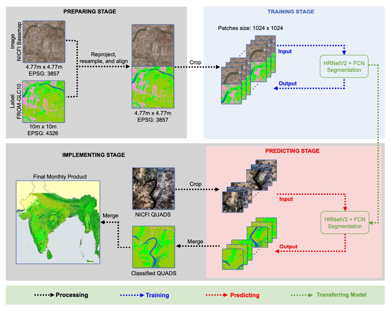
Table of Contents
“Using deep learning to monitor India’s disappearing forest cover”

Using satellite monitoring data, researchers have developed a deep learning algorithm that could provide real-time monthly land use and land cover maps for parts of India.
One of the 10 most forest-rich countries in the world, about 80.9 million hectares of trees cover India—about 25% of the nation—but this is a significant decline from years past. Between the 1890s and the 1990s, a combination of rapid economic development and overexploitation of local resources led to India losing nearly 80% of its native forest area. Now, as India’s forests still continue to disappear, researchers are focused on helping preserve what remains.
“Our work was done in an effort to help India’s government and industries improve the country’s attempts at forest sustainability,” said Ying Zuo, lead author of the project and a graduate student in earth sciences at The Ohio State University.
The land use monitoring system was trained using data provided by Norway’s International Climate and Forests Initiative (NICFI), an enterprise of the Norwegian government that aims to reduce the destruction of tropical forests, in part by providing high-resolution images of the world’s tropics. The product is generated using images from PlanetScope, a constellation of satellites that takes daily images of the entire globe.
By combining the NICFI products’ data with a global land cover map produced by Tsinghua University, their deep learning model was able to acquire a more detailed type of base map of the area.
“In an effort to combine two datasets into the same system, we resampled them into the same spatial resolution and aligned each pixel to create an image-labeled paired training dataset,” said Zuo. “The process helps us to assimilate the two datasets so they can be used to train our deep learning model.” This essentially merges thousands of small pictures into one larger base map.
After training their deep learning model on these new satellite images, the team was able to process 10 base maps of the area, ranging from January to October 2022.
The research poster was presented last week at the annual meeting of the American Geophysical Union. During her presentation, Zuo said that using these maps, the team was able to detect seasonal shifts across India, such as changes to barren land, how crop land was affected by monsoons during the rainy season, and the distribution of forests in mountainous regions.
One conclusion from the study was that it is vital for ecologists to more closely study the seasonal impact of monsoons on India’s forest cover. Understanding these seasonal changes can help scientists understand the effects of climate change on forests.
“As the average temperature of our Earth increases, natural hazards will become a lot more frequent, so having these maps at our disposal benefits everyone’s understanding of how this problem affects life on Earth,” she said.
Additionally, if the team can expand the timespan of these base maps over several years instead of several months, Zuo said better results could help scientists study other annual changes around the globe, such as floods.
“The characteristics of local forests and their surrounding habitats might likely be different in other regions,” said Zuo. “But with the help of more detailed datasets, our work could easily be used in areas of the world where detecting and alerting the public to forest degradation and its side effects need to become a priority.”
Co-authors of the poster include C.K Shum, Rongjun Qin, Yuanyuan Jia, Guixiang Zhang and Shengxi Gui, all researchers at Ohio State.
Research poster: Pan-India Land Use Land Cover Deep Learning Aided Classification Using NICFI Products
Citation:
Using deep learning to monitor India’s disappearing forest cover (2022, December 21)
retrieved 21 December 2022
from https://phys.org/news/2022-12-deep-india-forest.html
This document is subject to copyright. Apart from any fair dealing for the purpose of private study or research, no
part may be reproduced without the written permission. The content is provided for information purposes only.
If you liked the article, do not forget to share it with your friends. Follow us on Google News too, click on the star and choose us from your favorites.
For forums sites go to Forum.BuradaBiliyorum.Com
If you want to read more Like this articles, you can visit our Science category.