#NASA-NOAA satellite’s ‘night vision’ find wind shear battering Tropical Storm Vicky
“#NASA-NOAA satellite’s ‘night vision’ find wind shear battering Tropical Storm Vicky”
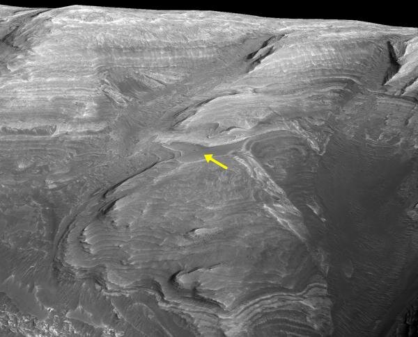
 and captured a night-time image of Tropical Storm Vicky that revealed wind shear was pushing the bulk of its clouds to the northeastern quadrant of the storm. Credit: NASA Worldview, Earth Observing System Data and Information System (EOSDIS)")
Infrared imagery is like having night vision, and NASA-NOAA’s Suomi NPP satellite provided a nighttime view of Tropical Storm Vicky that revealed outside winds are weakening the storm.
About Wind Shear
The shape of a tropical cyclone provides forecasters with an idea of its organization and strength. When outside winds batter a storm, it can change the storm’s shape. Winds can push most of the associated clouds and rain to one side of a storm. Outside winds from the southwest are pushing against Tropical Storm Vicky.
In general, wind shear is a measure of how the speed and direction of winds change with altitude. Tropical cyclones are like rotating cylinders of winds. Each level needs to be stacked on top each other vertically in order for the storm to maintain strength or intensify. Wind shear occurs when winds at different levels of the atmosphere push against the rotating cylinder of winds, weakening the rotation by pushing it apart at different levels.
NASA’s Night-Time View of Vicky’s Wind Shear
The Visible Infrared Imaging Radiometer Suite (VIIRS) instrument aboard Suomi NPP provided a nighttime image of Vicky on Sept. 15 at 0335 UTC (Sept. 14 at 11:35 p.m. EDT) using infrared imagery. That imagery revealed strong southwesterly wind shear was pushing the bulk of its clouds to the northeastern quadrant of the storm.
In the NHC Discussion at 5 a.m. EDT on Sept. 15, Eric Blake, senior hurricane specialist at NOAA’s National Hurricane Center in Miami, Fla. noted, “Vicky remains sheared this morning with strong upper-level winds causing any deep convection to be located northeast of the center. The low-level circulation has also become distorted as well, with new bursts of convection causing the mean circulation to re-form to the north.”
The image was created using the NASA Worldview application at NASA’s Goddard Space Flight Center in Greenbelt, Md.
Vicky’s Status on Sept. 15
NOAA’s National Hurricane Center (NHC) noted at 5 a.m. EDT (0900 UTC), the center of Tropical Storm Vicky was located near latitude 20.3 degrees north and longitude 30.1 degrees west. Vicky is 500 miles (800 km) northwest of the Cabo Verde Islands. Vicky is moving toward the northwest near 9 mph (15 kph), and a turn toward the west-northwest is expected within the next day or so, followed by a turn toward the west. Maximum sustained winds are near 50 mph (85 kph) with higher gusts. The estimated minimum central pressure is 1004 millibars.
Vicky’s Fading Forecast
Weakening is forecast due to strong upper-level winds during the next 48 hours, and Vicky is likely to degenerate into remnant low by Wednesday, Sept. 16.
About NASA’s EOSDIS Worldview
NASA’s Earth Observing System Data and Information System (EOSDIS) Worldview application provides the capability to interactively browse over 700 global, full-resolution satellite imagery layers and then download the underlying data. Many of the available imagery layers are updated within three hours of observation, essentially showing the entire Earth as it looks “right now.”
NASA Researches Earth from Space
For more than five decades, NASA has used the vantage point of space to understand and explore our home planet, improve lives and safeguard our future. NASA brings together technology, science, and unique global Earth observations to provide societal benefits and strengthen our nation. Advancing knowledge of our home planet contributes directly to America’s leadership in space and scientific exploration.
More information:
For updated forecasts, visit: http://www.nhc.noaa.gov
Citation:
NASA-NOAA satellite’s ‘night vision’ find wind shear battering Tropical Storm Vicky (2020, September 15)
retrieved 15 September 2020
from https://phys.org/news/2020-09-nasa-noaa-satellite-night-vision-battering.html
This document is subject to copyright. Apart from any fair dealing for the purpose of private study or research, no
part may be reproduced without the written permission. The content is provided for information purposes only.
if you want to watch Movies or Tv Shows go to Dizi.BuradaBiliyorum.Com for forums sites go to Forum.BuradaBiliyorum.Com
If you want to read more Like this articles, you can visit our Science category.