#NASA captures sequestered carbon of 9.9 billion trees with deep-learning and satellite images
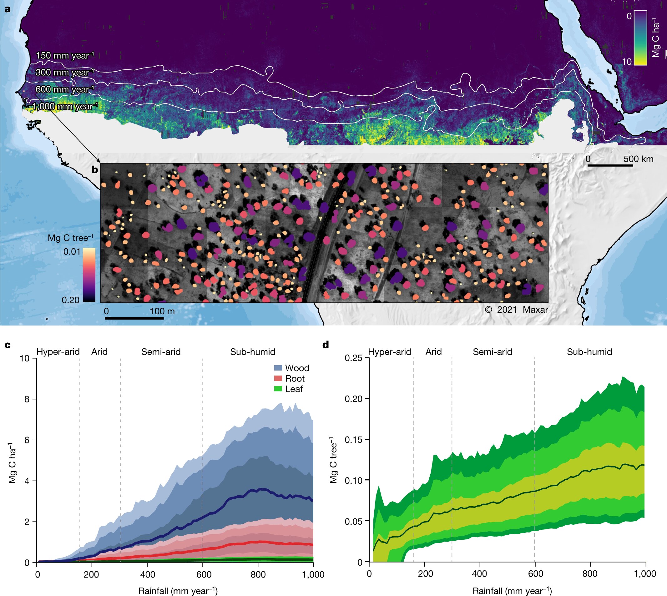
Table of Contents
“NASA captures sequestered carbon of 9.9 billion trees with deep-learning and satellite images”
 per hectare for 9,947,310,221 tree crowns from the 0–1,000 mm year −1 mean precipitation area. The isohyets mark the 150, 300, 600 and 1,000 mm year −1 rainfall zones (from north to south). b, Example showing the woody carbon stock of each single tree for an agroforestry area in Senegal. c, Mean tree carbon density at the 5th, 25th, 75th and 95th percentiles along the rainfall gradient for wood, foliage and root carbon. d, Mean carbon stock of individual trees at the 5th, 10th, 25th, 75th, 90th and 95th percentiles along the rainfall gradient. Our definition of a tree is a green leaf crown >3 m 2 with an associated shadow. Credit: Nature (2023). DOI: 10.1038/s41586-022-05653-6")
A NASA-led research team used satellite imagery and artificial intelligence methods to map billions of discrete tree crowns down to a 50-cm scale. The images encompassed a large swath of arid northern Africa, from the Atlantic to the Red Sea. Allometric equations based on previous tree sampling allowed the researchers to convert imagery into estimates of tree wood, foliage, root size, and carbon sequestration.
The new NASA estimation, published in the journal Nature, was surprisingly low. While the typical estimation of a region’s carbon stock might rely on counting small areas and extrapolating results upwards, the NASA demonstrated technique only counts the trees that are actually there, down to the individual tree. Jules Bayala and Meine van Noordwijk published a News & Views article in the same journal commenting on the NASA team’s work.
The initial expectation of counting every scattered tree, in areas that previous models often represented by zero values, was erased by large overestimations in other areas of the earlier assessments. In previous attempts using satellites, cropland, and ground vegetation adversely affected optical images. If radar was used, topography, wetlands, and irrigated areas affected the radar backscatter, predicting higher carbon stocks than the current NASA estimations.
Deep-learning based mapping
Researchers applied deep-learning-based tree mapping, manually trained on about 90,000 trees, to a data set of nearly 300,000 satellite images to measure more than 9.9 billion woody plants that displayed a shadow and a crown area greater than 3 square meters. Only features that showed a distinct crown area and an associated shadow were selected, which allowed the team to exclude small bushes, clumps of grass, rocks, and other misleading features.
The imaged regions were correlated to reflect four rainfall zones; hyper-arid, arid, semi-arid, and dry sub-humid—as rainfall affects carbon uptake and storage. While the foliage only represents 3% of the total dry mass, it was used as an indirect measurement to quantify the total mass. The proportion of root mass is, on average, 15–20% of the total mass and was also derived based on foliage.
Want to visualize the large tree-mapping dataset in an interactive browser format? The researchers did too, so they created a nifty viewer to work with and have made it publicly available here.
The ability to track the effectiveness of carbon sequestration could take on global significance in the fight against climate change. Reforestation is a leading method by which world nations have committed to offsetting their carbon footprint.
However, the practicality of those commitments has come under scrutiny from a team of 20 researchers working with the University of Melbourne’s interdisciplinary climate research initiative. They added up the obligations and discovered it would require planting trees on almost 1.2 billion hectares, an area larger than Europe or the US and roughly the amount of land currently used for crops globally.
Compton Tucker et al, Sub-continental-scale carbon stocks of individual trees in African drylands, Nature (2023). DOI: 10.1038/s41586-022-05653-6
Jules Bayala et al, Carbon stocks of billions of individual African dryland trees estimated, Nature (2023). DOI: 10.1038/d41586-023-00531-1
© 2023 Science X Network
Citation:
NASA captures sequestered carbon of 9.9 billion trees with deep-learning and satellite images (2023, March 5)
retrieved 5 March 2023
from https://phys.org/news/2023-03-nasa-captures-sequestered-carbon-billion.html
This document is subject to copyright. Apart from any fair dealing for the purpose of private study or research, no
part may be reproduced without the written permission. The content is provided for information purposes only.
If you liked the article, do not forget to share it with your friends. Follow us on Google News too, click on the star and choose us from your favorites.
For forums sites go to Forum.BuradaBiliyorum.Com
If you want to read more Like this articles, you can visit our Science category.