#Lidar network has potential to track wildfire pollutants across the continent
“#Lidar network has potential to track wildfire pollutants across the continent”

Residents of London are more than a thousand kilometers from raging wildfires in northwestern Ontario and Manitoba—but the fires’ impact on air quality was evident.
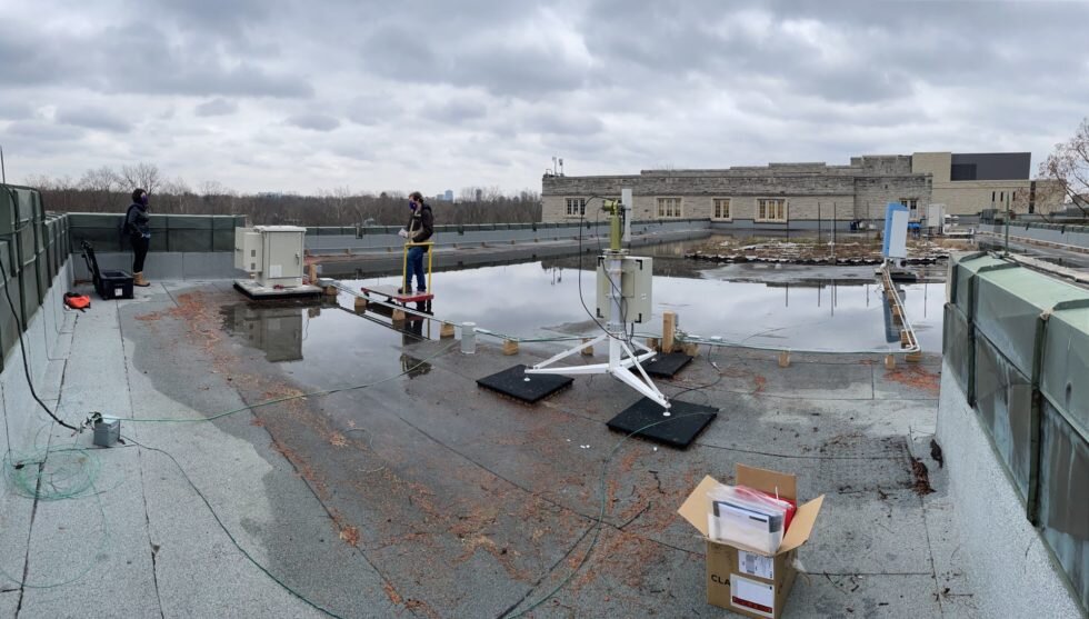
Detecting these potential health hazards is part of the objective of a network of micro-pulse lidars—one of which is installed on Western’s main campus—that track air particulates such as forest-fire smoke and other pollutants.
“Being able to track what’s coming into our air quality is really important for everyone living in that area,” explained Victoria Pinnegar, a graduate student in the department of physics and astronomy.
The layer of smoke over London was detected on July 29 at an altitude of three kilometers. The smoke persisted for about six hours before rain prevented the lidar from seeing through the clouds, Pinnegar noted in her one-page report, Northern Ont Smoke Over London
“With smoke from the Northern Ontario fire, what it’s been doing in southern Ontario and central Ontario is it’s been sitting on all our cities and causing air quality index to increase. It becomes slightly more dangerous to breathe the air because you’re unknowingly exposing yourself to smoke inhalation which, over a long term, can become an issue,” Pinnegar said.
The micro-pulse lidar installed at Western is part of the new Canadian micro-pulse lidar network (MPLCAN), consisting of four instruments installed, or to be installed, across eastern and northern Canada, including in Sherbrooke, Que., Halifax, and in Eureka, Nunavut. A fifth one, from the University of Toronto, recently joined the network as well. Together, they join a global network, the NASA micro-pulse lidar network (MPLNET).
MPLCAN does not typically send out smoke alerts, Pinnegar said, but its data is openly accessible on the NASA MPLNET website. The network is also working in partnership with Environment and Climate Change Canada.
“Right now, we are building up our data collection so that in the future, we may be a better resource for (stakeholder) groups,” she said.
Pinnegar’s team, headed by Western physics professor Robert Sica, also detected smoke over London in June from wildfires in British Columbia, which stayed in the atmosphere above London for hours at an altitude of about 15 kilometers.
“But it’s not only the northern Ontario fires and B.C. fires that will affect us; it will be across all North America,” Pinnegar noted. Wildfires that burned through California and Oregon last year, for example, were also detected on lidars in London and Sherbrooke.
Lidar—short for ‘light detection and ranging’ – provides a different way to measure atmospheric aerosols, which are suspended solid, liquid or mixed particles in the air, explained Sica, who is also chair of the department of physics and astronomy. Measuring and studying aerosols is important for research into weather and climate change.
Lidar measurements offer ‘profiling’, which means providing a picture of particulate presence in both time and altitude.
“The part that I’m excited about is I think these kinds of technology—meaning lidars—have a great potential for tracking forest fire smoke, and we will be pushing to get denser networks of these lidars in regions where there are forest fires often,” said Sica. He added this would allow tracking of smoke from wildfire events “much like you can track thunderstorms,” providing important information about potential health risks for affected residents.
“We don’t always see forest fire smoke, but we quite often see events that are related to pollution, and pollution, a lot of times is not all local; you’re getting pollution from somewhere else,” Sica said.
The physics professor said he hopes in the future the lidar network will be expanded to Western Canada, where many forest fires take place each year. “Because the real strength in these kinds of measurements we’re doing is having networks, not just one or two sites; the more sites you have, the more interesting science you can do.”
Wildfire smoke in New England is ‘pretty severe from public health perspective’
Report: news.westernu.ca/wp-content/up … moke-Over-London.pdf
Citation:
Lidar network has potential to track wildfire pollutants across the continent (2021, August 5)
retrieved 5 August 2021
from https://phys.org/news/2021-08-lidar-network-potential-track-wildfire.html
This document is subject to copyright. Apart from any fair dealing for the purpose of private study or research, no
part may be reproduced without the written permission. The content is provided for information purposes only.
If you liked the article, do not forget to share it with your friends. Follow us on Google News too, click on the star and choose us from your favorites.
For forums sites go to Forum.BuradaBiliyorum.Com
If you want to read more Like this articles, you can visit our Science category.