#Famous landmarks in Arizona
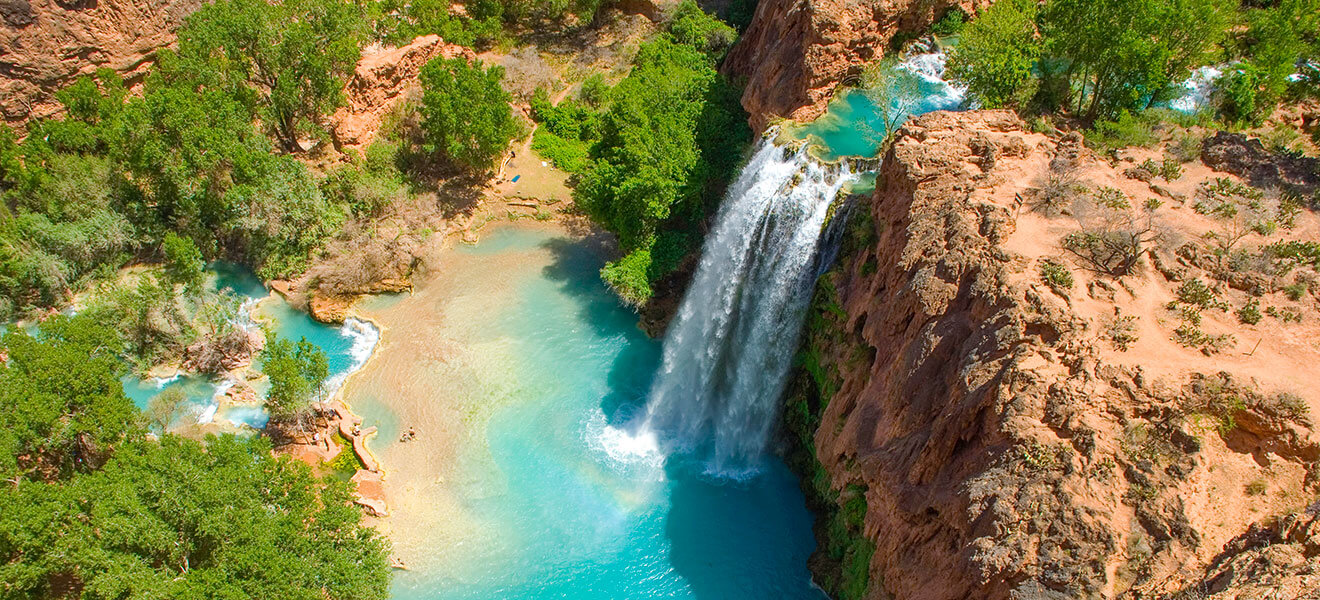
Table of Contents
“#Famous landmarks in Arizona”
This article of the World Landmarks series examines the most famous landmarks in Arizona. From the world-famous Grand Canyon and the other stunning canyons to the Hoover and Glenn Canyon Dams, Arizona is full of natural wonders and impressive human-made landmarks. As usual in these posts, we invited a few fellow bloggers to share some of their favorite Arizona landmarks.
From the Navajo Nation to the Deserts and saguaros, there are various things Arizona is famous for. Yet, the landmarks in Arizona are majestic and contribute significantly to Arizona’s reputation as one of the best outdoor destinations in America. If you love outdoor travel, visiting Arizona will be a bliss.
So, without further ados, let’s unravel some of the most famous landmarks in Arizona.
Natural Landmarks in Arizona
Grand Canyon
The Grand Canyon is the most famous of the landmarks in Arizona. It is easily one of the most famous natural wonders of the USA and the world. As the name suggests, the Grand Canyon is huge, it’s among the largest Canyons in the world, but it’s not only the gigantic size that attracts people, it’s also a stunning location with layers of different colored rocks. Sunsets and sunrises give the Grand Canyon a whole other beauty.
Encompassing 277 miles (446 km) of the Colorado River and adjacent uplands, the Grand Canyon is a steep-sided canyon up to 18 miles (29 km) wide and a depth of 6,093 feet (or 1,857 meters). Scientists estimate that it took about 5 to 6 million years for the Colorado River (and its tributaries) to expose about two billion years of Earth’s geological history cutting through layers of colored rocks, some of them are recognized among the oldest exposed rocks on earth.
The Grand Canyon is a national park since 1919 and a UNESCO World Heritage site since 1979. With roughly 6 million visitors every year, it is the second most popular national park in the USA. If the weather allows, the south rim is open year-round, while the north rim is usually open only from May to October.
The Grand Canyon and its national are so big that we could argue that it’s not only one landmark but several, and that’s why we have included a few specific locations in this Landmarks list, like the Indian garden, Havasu Falls, and the south rim lookouts. They are significant Arizona landmarks on their own.

Grand Canyon South Rim lookouts
By Shweta Singhal from Zest In A Tote
When planning a trip to the Grand Canyon, one of the 7 natural wonders in the world, we need to consider which part of the canyon you would be visiting. Having visited the Grand Canyon South Rim, I can vouch for the fact that it has some of the most majestic viewpoints.
The Information Centre at Grand Canyon Village is an excellent stop for information on the best viewpoints around the South Rim. Many folks do a day trip to the Grand Canyon, but I would highly recommend that you do an overnight trip at the least to enjoy both the star-studded night and the dawn colors. The break of the dawn and the spectacular sunrise has to be one of my most cherished memories of the trip to Arizona.
Yapavai, Hopi and Navajo / Desert points are the best viewpoints for watching the sunrise at the Grand Canyon South Rim. We needed a car to drive to Navajo and Desert View Points, as no shuttle goes there. From our hotel, we drove towards Desert View Point towards the East Rim. We then stopped at various points on this road to see the sky change from a fiery red to a paler orange and yellow.

Saguaro National Park
By Candice from CS Ginger
Saguaro National Park was established as a national park in October of 1994. However, it was initially preserved as a national monument by President Herbert Hoover in 1933. The saguaro is one of the longest-living cacti, and some of the cacti in the park are 150-175 years old.
The saguaro cactus is only found in a small part of the United States, making this an essential part of the landscape of not only Arizona but the western United States.
Along with the saguaro cacti, the national park is home to more than 1 160 species of plants along with mammals, amphibians, and reptiles.
The best way to see the park is by exploring the hikes in Saguaro National Park. No matter your skill, level there are great trails to hike on. They range from easy paved paths to long, overnight backpacking trips. The Valley View Overlook Trail is a nice 0.8-mile trail that will take you through the desert and saguaro cacti. The Signal Hill Petroglyphs trail is an easy, out and back trail that features some beautiful petroglyphs.
Saguaro National Park is just outside Tucson, Arizona. Tucson is about two hours south of Phoenix, Arizona.

Cathedral Rock, Sedona
By Brittany Sawyer from Travel by Brit
Cathedral Rock is a natural sandstone butte that’s situated along the skyline in Sedona, Arizona. It’s one of the most photographed (and famous!) landmarks in Arizona.
However, Cathedral Rock is more than just a landmark—it’s also a popular spot for hiking in Sedona. In fact, the Cathedral Rock Trail is one of the best things to do in Sedona, AZ, and trekking up the mountain is the only way you can access this scenic attraction!
The Cathedral Rock Trail is a challenging 1.2-mile hike that requires some rock scrambling and a steep incline, but you’ll be greeted with spectacular views of Cathedral Rock and the surrounding area once you reach the top!
To get to the Cathedral Rock Trail from Phoenix, you’ll need to drive through the Village of Oak Creek in Sedona and then drive west on Back O Beyond Road. You’ll find the parking lot just off the road after going for a few miles.

Meteor Crater
By Melissa from Navigation Junkie
Although just a 30-minute drive outside of Winslow, AZ, a visit to Meteor Crater Natural Landmark in Arizona will transport you to a whole other world. Meteor Crater Natural Landmark is a 750 ft. deep crater created when a 150 ft. wide meteorite crashed into the Earth 50,000 years ago.
The crater is one of the most preserved impact craters in the world, making it essential for scientists to research the impact of the meteorite on Earth and research meteorites in outer space.
You can enjoy a self-guided tour of the crater with the outdoor viewing decks or take a guided rim tour to learn more about the crater’s history and how it has helped with space research.
When visiting, you will have access to the museum and 4D Collision theater. The museum outlines the history of the meteorite that created the crater with a small piece of the actual meteorite on display. The 4D theater is a fun experience that takes you from the crater up into space.
Meteor Crater is best reached by driving as it is found off exit 233 on Interstate Highway 40. After getting off the exit, you will follow Meteor Crater Road through an almost empty desert until you reach the visitor center and crater behind it.

White Pocket
By Meg Atteberry of Fox in the Forest
Located deep inside the Vermillion Cliffs Wilderness area, White Pocket is a sea of striking pink, orange, and red hues that will have you wondering if you were somehow transported into the heart of Mars. The entire place is made up of strange-looking Navajo sandstone formations, sherbert-colored rocks, and cauliflower-like white puffs of rock, all of which make the landscape look other-worldly.
While the hike to reach White Pocket may not be as famous as The Wave, its beauty falls into a similar category and is a must for anyone visiting Arizona searching for some serious desert goodness.
From Page, head east on Highway 89 and exit for House Rock Valley Road. Continue South for about an hour until you reach Pine Tree Road or BLM Road 1017. Follow the road until you get to Road 1087. Take 1087, where the road will soon turn into deep sand for the rest of the trip. Next, head north at the 1086 Junction until you reach White Pocket. Note that you need a 4WD with decent clearance to get to White Pocket, making it a destination only for true adventurers at heart!

Monument Valley
By Agnes from The Van Escape
An icon of the Wild West. One of the Southwest’s most famous must-see natural landmarks on a trip to the US. Setting for the best western movies of all time. And a sacred place to Native Americans.
Monument Valley in Arizona is truly a picturesque and magical place. The park is located on the Colorado Plateau and lies entirely within the Navajo Indian Reservation. The Navajo Indians administer the Valley as Navajo Tribal Park. It is part of the Four Corners area. From Page, Arizona to Monument Valley is 125 miles, from Four Corners Monument – 105 miles.
Despite its name, the Valley is not a valley but an area where aeolian erosion has created rock formations in the form of rock pinnacles, carpentry, plateaus, mesas, and steep, isolated formations called buttes. The red color of the rocks is due to two types of Wingate sandstone and Navajo sandstone that dominate Monument Valley. These rocks are saturated with large amounts of iron oxides. The rocks are up to 300 m high from base to top, and the ground is at an average elevation of 1 855 m above sea level.
Visitors can drive through the park on a 17-mile (27 km) dirt and rough loop road (a 2-4 hour trip). Horseback riding and guided tours are also possible in the park. Park Entry Fee is $20 per vehicle for up to 4 people.

Tonto Natural Bridge
By Maggie Turansky from The world was here first
One of the most underrated landmarks in Arizona has got to be the incredible Tonto Natural Bridge. Located outside of the town of Payson in Northern Arizona, this makes for an excellent stop when driving north to the Grand Canyon from Arizona’s capital.
This natural stone archway stands at 56 meters (183 feet) tall and 120 meters (400 feet) wide at the widest point and is considered the largest travertine bridge globally. Despite these feats, this landmark is still relatively unknown even by Arizona locals, meaning that you can beat the tourist crowds that flock to other popular places in the state.
Surrounded by beautiful pine forest and a number of different hiking trails, visiting the Tonto Natural Bridge State Park is an excellent addition to any itinerary in Arizona. The facilities and trails are well-maintained, and there are countless different routes and lookouts where you can see the bridge from different angles.
So if you’re looking for a unique landmark in Arizona, look no further than the Tonto Natural Bridge!

Petrified Forest National Park
By Jessica Schmit from Uprooted Traveler
Tucked away in the Northeastern part of Arizona, Petrified Forest National Park is an absolute hidden gem that should not be missed. This national park is located about an hour and a half east of Flagstaff, along the famed Route 66. While its landscape may not be as dramatic as its more famous neighbors, like the Grand Canyon, its scenery is nonetheless breathtaking, with desert landscapes stretching onto the horizon, technicolor badlands, and forests of ancient crystalized wood.
One of its unique perks is its compact footprint- while some national parks may take you weeks to fully explore, you can easily see most of the park’s main attractions, with plenty of hikes perfect for beginners and overlooks, in just a short visit. For one of the coolest hikes in the park, stop at the Blue Mesa Trail, where you’ll follow a path below the rim of a mesa and between dozens of indigo-hued badlands towering overhead.
If you instead want to get to know the park’s namesake geology a bit better, head to the Crystal Forest Trail, where a stunning supply of petrified wood, all millions of years old, lay scattered across the park’s rolling hills. So whether you’re into epic landscapes, fascinating geology, or just some good old-fashioned Americana, Petrified Forest should be added to your Arizona bucket list.

Arizona Landmarks – Native-amarican Ruins
Walnut Canyon National Monument Arizona
By Maria Haase from San Diego Exploreroad
This 600 ft deep canyon is located just outside of Flagstaff, Arizona, and it is home to ancient Native American cave dwellings. This is one of the must-see monuments in Northern Arizona and one of the top things to do in Flagstaff.
There are two ways to explore Walnut Canyon. You can either walk along the Rim Trail, which gives you sweeping vistas over the canyon. The rocks are covered by Ponderosa pine, and the views give you a feel for the vast Colorado Plateau that stretches all the way to the Rocky Mountains.
Even more exciting yet quite strenuous is the Island Trail that leads you down into the canyon. The trail is only a mile long but very steep. It mainly consists of 730 steps that will lead you down into Walnut Canyon and right to the 800+-year-old cave dwellings of the Sinagua tribe. This sight is definitely worth the effort of the hike.
Important: Make sure to bring plenty of water, rest, and take your time. Walnut Canyon lies at 7000 feet above sea level, so the air is relatively thin. Also, skip this hike during the summer unless you are used to exercising in scorching conditions.

Navajo National Monument
James Ian from Parks Collecting
Navajo National Monument is found in the northwestern part of the Navajo Nation in northern Arizona, halfway between Page and Monument Valley. It makes a great stop if you’re traveling between the two.
The national monument is home to three cliff dwellings, Keet Seel, Betatakin, and Inscription house, in the Tesgi Canyon system. Originally occupied by the Ancestral Puebloan people in the mid-1200s, the entire area was abandoned at the end of the thirteenth century. No one is exactly sure why, but a prolonged drought is one possible reason.
Keet Seel is considered one of the best-preserved larger cliff dwellings in the Southwest. At its peak, it housed up to 150 people. It can only be visited on a 17-mile roundtrip, backcountry, ranger-led hike. This can be done as a day trip or an overnight trip; there is a primitive campsite nearby. It requires climbing a long steep ladder from the canyon floor to get up into the dwelling but is well worth the effort.
The other cliff dwelling that can be visited is Betatakin, which is closer and can be reached by a steep 3-mile (3-4 hours) ranger-led hike. This dwelling is a little smaller (it housed up to 125 people) and not quite as well-preserved, but it is still spectacular. Inscription House is not open to the public.
If you don’t want to do a long hike, it is possible to take a self-guided walk along the easy 1.3-mile out-and-back Sandal Trail to an overlook with great views of Betatakin 0.25 miles away across the canyon.
There are a couple of other easy hikes in the area where you don’t see any cliff dwellings, and a Visitor Center and small gift shop, as well as a campground.

Indian Garden
By Jenna from Up and Away Magazine
Visible from the South Rim of the Grand Canyon, Indian Garden stands out as a strikingly green oasis amongst an otherwise endless sea of red rock. Located approximately 4.5 miles down Bright Angel Trail, the campground brings sweet relief to tired hikers and backpackers with its cool creek, shady trees, and a cluster of picnic tables.
Unsurprisingly, the name Indian Garden was coined by European-Americans who “discovered” the area in the 1800s only to realize indigenous tribes had previously cultivated it. Nearby petroglyphs reveal that humans lived in the region as far back as 13,000 years ago, and remnants of numerous seasonal farming structures (likely built by the Puebloans) were discovered in Indian Garden itself. Today, the campground is managed by the National Park Service and includes a ranger station, emergency phone, toilets, and potable water.
If you’re looking for a “must-do” Grand Canyon day hike, Indian Garden is it. While challenging, hiking to the campground is very attainable if you’re reasonably fit. The Bright Angel Trail is well maintained, and there are several water stations and bathrooms along the way. Start early to avoid having to make the grueling ascent back out of the canyon during the hottest part of the day. Alternatively, overnight at Indian Garden as part of a longer Grand Canyon rim-to-rim adventure, easily one of the most bucket-list-worthy hikes in the USA.

Montezuma Castle
By Dee from Vanilla Papers
Montezuma Castle is a cluster of dwellings tucked into a mountain that has survived for over 700 years. It’s now a breathtaking Arizona wonder that’s a national monument and an insight into pre-Columbian cultures.
About a 90-minute drive north of Phoenix (take the I-17 N), Montezuma Castle makes a great day trip for exploring Arizona’s history and nature.
Start at the visitor’s center and the small exhibit about the Southern Sinagua, a pre-Columbian culture that once thrived here and built the dwellings. The collection includes pottery and tools for grinding corn that showcase the daily life of the Sinagua.
European colonizers assumed the dwellings were connected to the famous Aztec emperor, so Montezuma Castle got its inaccurate name.
But Montezuma Castle is a cluster of expertly built dwellings accessed by a series of ladders. The dwellings have survived for centuries inside a natural alcove that protected them from the harsh elements.
Montezuma Castle is perched some 27 meters up a limestone cliff and possibly built so high to escape annual floods. But at some point, it was abandoned – maybe because of drought or clashes with the Yavapai.

Wupatki National Monument
By Sydney from A World in Reach
Located just 35 minutes north of Flagstaff, Wupatki National Monument is a spectacular monument home to various Native American archaeological sites.
The area surrounding Wupatki National Monument is very picturesque, with pueblos surrounded by red rocks and prairies. Several different easy hiking trails take you along to the various pueblos and offer rewarding views. The most popular pueblo in the monument is the 900-year old Wupatki Pueblo. Visiting the pueblo provides a fascinating insight into life in the 1100s when the pueblos were inhabited.
While you can explore the monument on your own, there are also guided tours of the National Monument offered from October through April. This is a great way to get a more in-depth look at the history of the monument. If you’re up for a more strenuous hike, consider going on one of the guided Crack in Rock Hikes – a two-day trek through an isolated area of the monument.
Wupatki National Monument is located off US-89 near Sunset Crater Volcano National Monument. You can easily plan a visit either on your way to or from the Grand Canyon from Flagstaff.

Famous Landmarks in Arizona – Phoenix metro
Chase Field
By JJ Haglund from The Minivan Bucket List
When most people think of Arizona landmarks, they think of the Grand Canyon and other natural wonders (as evident by most places on this list). But there is something else for which Arizona is known to be something of a mecca: baseball.
Phoenix is home to the Cactus League when fifteen Major League Baseball teams come to the area for spring training. Year-round, the resident MLB team is the Arizona Diamondbacks. They play at Chase Field, which is somewhat of a modern marvel – it’s a baseball stadium with a retractable roof to protect from the stifling sun and desert heat. It also has one of the most unique features in all of the pros – a swimming pool in the outfield.
Imagine hanging out in the pool and catching a home run ball! The stadium was built in 1998 when the franchise was established as an expansion team. Just three years later, they won the World Series with pitcher Randy Johnson leading the team.
Catching a Diamondbacks game here is one of the best things to do in Phoenix, even if you’re not a huge baseball fan.

Camelback Mountain in Phoenix
By Danielle Fairbanks from Danielle Outdoors
When people think of visiting Phoenix, Arizona, climbing Camelback Mountain is always at the top of the list. This beautiful iconic-shaped mountain sites in Scottsdale, making it easily accessible and is visible for miles. There are two trails on Camelback Mountain- Cholla Trail on the East Side and Echo Canyon on the West Side. I suggest Echo Canyon-it’s a classic. This short 1.25-mile roundtrip trail takes you climbing giant boulders, and using a metal road to pull yourself up is exhilarating. At the top, you’ll be able to see Downtown Phoenix and the Valley’s surrounding mountains.
Getting to the Echo Canyon Trailhead is easy, but parking is limited. I’ve found myself circling the parking lot many times to snatch a spot. If you’re visiting near Scottsdale, I HIGHLY suggest taking an Uber/Lyft to get there. If you drive yourself, carpool, and come when it isn’t as busy (early morning, late afternoon, etc.). Beware- it can get HOT in Phoenix. I don’t suggest hiking when the temperature is above 90 degrees.
You won’t regret adding this famous Arizona Landmark to your next trip to the desert.

Heard Museum
By Kenny from Knycx Journeying
Phoenix is the capital of Arizona and nicknamed “the Valley of Sun” because the city is surrounded by mountains, with desert weather that gives it an annual eighty-five percentage of sunshine.
To get there, the Phoenix Sky Harbor is the major travel hub that connects Arizona with the rest of the world. Most of the natural treasures in the state are located on the outskirts of the city, and the city center is a great stopover to get in touch with native American art and history.
The Heard Museum is one of the most prestigious art museums, showcasing rich Native American culture. It was founded in 1929, and noted architect Bennie Gonzales designed part of the mansion.
Today, Heard Museum welcomes about 250,000 visitors a year; It has an impressive collection of over 40,000 pieces of Southwestern art exhibit, ranging from historic kachina dolls, clothing, pottery to authentic tools of indigenous Americans.
The museum is within walking distance from the tram station of Encanto/Central Ave. About half a mile away, the Phoenix Art Museum is another important art facility in Phoenix with an extensive art collection from well-known American artists like Georgia O’Keeffe to the European ones like Claude Monet.

Arizona Landmarks – Page region
Antelope Canyon
By Contributed by Krystianna from Volumes & Voyages
One of the best famous Arizona landmarks is none other than Antelope Canyon. It’s located right in Page, and the only way to go right into the canyon where all the best photos can be taken is on a tour because the Navajo Nation owns it.
Antelope Canyon is one of the most picturesque natural places in Arizona. It is a must-visit when going on a road trip in this part of the country to other places like Bryce Canyon National Park and Horseshoe Bend.
This beautiful slot canyon has two different sections: upper and lower. The majority of people will opt to visit Upper Antelope Canyon because it’s the more popularly photographed section. There is also more room on the canyon floor because it’s shaped like an “A.”
On the other hand, because Lower Antelope Canyon is lesser-visited, it’s easier to get tickets to tour this part. Lower is opposite of Upper and is shaped like a “V,” so there’s less room on the canyon floor, but a lot more light gets through into the canyon.
Both are absolutely worth visiting if you can. Just make sure you book tickets a few months in advance! However, if you’re on a time crunch, opt to visit Upper Antelope Canyon because it’s a bit more accessible because it is easier to walk through.

Horseshoe Bend, Page
By Val from VoyageswithVal
Horseshoe Bend is one of the iconic landmarks of Arizona. It is known for its unique horseshoe shape, carved from the Colorado River, and it is one of the best things to do in Page, Arizona.
Drive 5 miles south of Page, and you can follow the signs to the parking lot for Horseshoe Bend. There is a $10 fee to enter the lot to help maintain the area. The trail to the overlook is a 0.7 mile, mostly paved walk. It is exposed to the sun, so bring water, but this trail should be accessible for most people. There are a few artificial structures with shade on the way if needed.
The actual viewpoint opens up, and visitors walk along much of the cliff to look down into the deep canyon. Be careful to stay back from the edge, as there are very few railings.
A few things to know before visiting Horseshoe Bend include that the area can get quite crowded. It also does not take long to see the bend unless you stay for a sunrise or sunset photo. The best time to visit is in the morning when the day is still cool, rather than the heat of midday.

Glen Canyon Dam
By Milijana Gabrić from World Travel Connector
Completed in 1966, the Glen Canyon Dam on the Colorado River near the town of Page is one of the most famous landmarks of Arizona.
The 710 ft (220 m) high Canyon Dam in Arizona is the second-highest dam in the US, following only Hoover Dam in Nevada. But most importantly, Glen Canyon Dam is one of the most significant structures in the US. The dam creates Lake Powel that is the second-largest water reservoir in the US. The lake provides water supply and electricity to several American states (Colorado, Nebraska, Nevada, Utah, California, Arizona, and New Mexico.). Monumental Glen Canyon Dam is popularly known as ‘The White House’. President Dwight D. Eisenhower pushed a button from the White House to mark the official start of the construction in 1956.
Impressive Glen Canyon Dam is amid rugged desert scenery just outside of the town of Page in northern Arizona. It is part of the Glen Canyon Recreational Area. The dam is also a few minutes drive from Horseshoe Bend, Antelope Canyon in Arizona near the Utah border. Head to the Carl Hayden Visitors Center and take a Glen Canyon Dam tour if you want to visit the dam. The 45 min tour includes visits to the interior and the top of the dam and provides many great insights into the dam history and the science of the water supply.
So, if you want to see one of the most famous man-made structures in the US, plan a visit to Glen Canyon Dam in northern Arizona.

Lake Powell
By Megan Johnson from Red Around the World
While most Lake Powell is in Utah, the easiest way to visit is via Page, Arizona. It’s easiest to fly into Flagstaff, Phoenix, or Las Vegas then rent a car to get here. Lake Powell started filling in 1963 when the Glen Canyon Dam was finished being built.
Here you’ll have access to Wahweap Marina and Antelope Point Marina, tons of kayak rental companies, and plenty of boating options, whether it’s renting one, joining a public tour, or doing a private tour. You can also rent houseboats to spend a few days on the lake.
Lake Powell is actually a reservoir, and it’s massive. As in, 186 miles from the Glen Canyon Dam to the other end, more shoreline than the west coast of the US, huge. It takes five hours to boat from one end to the other, at least, and at least twice that in a houseboat. It’s an environmentalist’s nightmare and a boater’s paradise.
If you’re not renting a boat or kayaking, there isn’t much to do on land, but you can either relax on Lone Rock Beach or get some great views of it from the Wahweap view, Alstrom Point (with a proper vehicle), or Skylight Arch. Some of the best things to see at the south end of the lake are Antelope Canyon (the same canyon as on land, but this part will look very different), Navajo Canyon, Padre Bay, and Labyrinth Canyon.

Landmarks Arizona – Human-made
Hoover Dam
Located on the Colorado River on the border with Nevada, the Hoover Dam was a massive project and it still is an incredible engineering feat. Until 1948 is was the world’s largest hydroelectric power station and naturally, it is one of the most famous landmarks in Arizona and Nevada.
Constructed between 1931 and 1936, it is 726 feet high and 1 244 feet long. it was the largest dam in the world when it was built. Today, the Hoover Dam is a huge tourist attraction receiving more than one million visitors per year. The dam’s crest was used to cross the Colorado River until 2010 when the new Hoover dam bridge was opened. This bridge is one of the best viewpoints to the Dam and Lake Mead.
When full, Lake Mead is the largest reservoir by volume in the United States. At full capacity, it is 112 miles long, 532 feet deep, and has roughly 247 square miles of surface area. However, the lake doesn’t reach full capacity since 1983 due to increased water demand and droughts. In June 2021, lake mead was only at 35% capacity, an all-time low record.
Visiting the Hoover Dam is free, but if you want to take a tour or enter the visitor center you’ll need to buy a ticket. If you buy the tour, the visitor center ticket is always included. During the 1-hour tour to the dam, you get to visit the powerplant and passageways within the dam itself. The visitor center is located on the Nevadan side but it features an exhibit gallery and a film about the construction of the dam.
The Hoover dam is more than a famous landmark it is pivotal to the economy of both states providing irrigation water, controlling floods, and producing electricity. One can say it completely changed the two states, presenting a water source to a deserted area. Without the dam and the reservoir, it would be impossible for a city like Las Vegas to exist.

Four Corners Monument
The four corners monument marks the point where four USA states, Colorado, Utah, Arizona, and New Mexico, meet. This is the only quadripoint (point on Earth where four distinct territories meet) in the USA.
The monument attracts thousands of tourists each year, who want to visit this geographic landmark, and if possible, be in the four states at the same time.
This popular landmark consists of a round bronze disc with the demarkations of the four states and cycling the disc, you can read “here meet in freedom under God four states.” Enclosing the four corners monument, you will find the flags of Arizona, the Navajo Nation, Utah, Ute Mountain Ute Tribe Reservation, Colorado, New Mexico, Navajo Nation (third instance), and the flag of the United States.
Controversially the monument doesn’t actually mark the exact locations where the four states meet; the exact point is about 1800 feet east of where the Four Corners marker had initially been intended to be located by the US Congress in 1863.

London Bridge, Lake Havasu City
By Tara Schatz from Back Road Ramblers
Did you know that you can visit a little piece of the British Isles in Arizona? Thanks to a millionaire with foresight and some fancy engineering, the London Bridge, originally built to span the River Thames in 1831, has a permanent home in Lake Havasu City, Arizona.
Lake Havasu was created in the 1930s when the Parker Dam was built on the Colorado River. Still, Lake Havasu City didn’t spring up until thirty years later when chainsaw tycoon Robert McCulloch bought 3,500 acres of desert with the hopes of creating a city of endless sunshine and gorgeous mountain views.
McCulloch won the London Bridge at auction for $2,460,000 and paid another $240,000 to be dismantled brick by brick and reconstructed in his fledgling city. The London Bridge officially opened in 1971, with much celebrating and fanfare. Today, London Bridge is a significant tourist attraction rising out of the desert and surrounded by the thriving Lake Havasu City.
The London Bridge recently celebrated its 50th anniversary in Lake Havasu City and holds the World’s Largest Antique ever sold record. The best way to visit the London Bridge is to fly into Las Vegas, rent a car, and drive 2.5 hours south.
The London Bridge may have put Lake Havasu City on the map, but the mild temperatures, turquoise waters, and mountain views make it a perfect destination for anyone who needs to escape the cold for some fun in the sun.
Taliesin West, Scottsdale
By Theresa L. Goodrich from The Local Tourist
Midwestern winters can be brutal, and Arizona has long been a popular snowbird destination. One of the state’s most famous seasonal residents was Frank Lloyd Wright. The renowned architect would escape the snow and cold in Scottsdale, where he built Taliesin West, his warm-weather counterpart to his Spring Green, Wisconsin, school and studio.
Located in Scottsdale near the McDowell Sonoran Preserve, this famous Arizona landmark is one of the eight Frank Lloyd Wright sites inscribed on the UNESCO World Heritage List. The complex is unique; one of the architect’s claims to fame was adapting designs based on their environment. Where Taliesin in Wisconsin is definitive prairie style, the Arizona complex is adapted to the desert.
Construction began in 1937, and as was typical of Wright, he and his students continued refining the site until his death in 1959. Taking a tour of Taliesin West is one of the best things to do in Scottsdale. There are several different tours; some are as short as an hour and others are two and a half hours. During these tours, not only do you learn about the architecture that made Wright famous, but also about the personal drama that surrounded his tumultuous life.

If you liked the article, do not forget to share it with your friends. Follow us on Google News too, click on the star and choose us from your favorites.
For forums sites go to Forum.BuradaBiliyorum.Com
If you want to read more Like this articles, you can visit our Trip & Travel category.