#NASA nets Dolphin as an extratropical storm
“#NASA nets Dolphin as an extratropical storm”
. Image Courtesy: NASA Worldview, Earth Observing System Data and Information System (EOSDIS).")
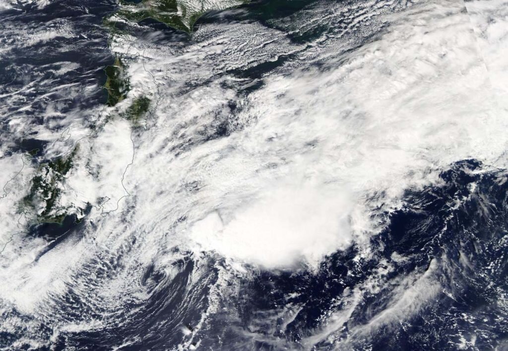
NASA’s Aqua satellite caught a visible image of Dolphin after it passed east central Japan on Sept. 24, where it became an extratropical storm in the Northwestern Pacific Ocean.
At 11 p.m. EDT on Sept. 23 (0300 UTC on Sept. 24) the Joint Typhoon Warning Center (JTWC) noted, “Animated multispectral satellite imagery shows the ragged low level circulation has become quasi-stationary and fully exposed as the rapidly decaying central convection sheared 140 plus nautical miles to the east-northeast. Analysis indicates that tropical cyclone Dolphin now fully embedded in the baroclinic zone and has become extra-tropical.”
Strong vertical wind shear from the west-southwest was battering Dolphin and pushing the bulk of clouds to the east-northeast. Wind shear occurs when winds outside of a tropical cyclone blow against it and adversely affect its circulation by displacing clouds and precipitation and weakening the system.
Dolphin on Sept. 24
At 11 p.m. EDT on Sept. 23 (0300 UTC on Sept. 24) the center of Dolphin was located near latitude 33.1 degrees north and longitude 141.8 degrees east. That is about 175 nautical miles southeast of Yokosuka, Japan. Dolphin was barely moving to the south at 1 knot and had maximum sustained winds near 30 knots (35 mph/55 kph).
NASA’s Aqua satellite view
The Moderate Resolution Imaging Spectroradiometer or MODIS instrument that flies aboard NASA’s Aqua satellite captured a visible image of Dolphin at 11:35 p.m. EDT on Sept. 23 (0335 UTC on Sept. 24). The image showed the storm appeared more elongated. That is an indication that the storm was weakening and it had become extratropical.
What is an extra-tropical storm?
Often, a tropical cyclone will transform into an extra-tropical cyclone as it recurves toward the poles (north or south, depending on the hemisphere the storm is located in). An extra-tropical cyclone is a storm system that primarily gets its energy from the horizontal temperature contrasts that exist in the atmosphere.
Tropical cyclones have their strongest winds near the earth’s surface, while extra-tropical cyclones have their strongest winds near the tropopause—about eight miles (12 km) up. Also, tropical cyclones, in contrast, typically have little to no temperature differences across the storm at the surface and their winds are derived from the release of energy due to cloud/rain formation from the warm moist air of the tropics.
Dolphin’s final forecast
Forecasters at the JTWC noted, “The remnant storm-force cold-core low [pressure area] will drift slowly poleward [north] and deeper into the cold polar air mass. There is also a distinct possibility that the cyclone will remain quasi-stationary and dissipate.”
NASA finds Tropical Storm Dolphin going swimmingly
Citation:
NASA nets Dolphin as an extratropical storm (2020, September 24)
retrieved 24 September 2020
from https://phys.org/news/2020-09-nasa-nets-dolphin-extratropical-storm.html
This document is subject to copyright. Apart from any fair dealing for the purpose of private study or research, no
part may be reproduced without the written permission. The content is provided for information purposes only.
For forums sites go to Forum.BuradaBiliyorum.Com
If you want to read more Like this articles, you can visit our Science category.