#NASA’s tracking Hawaii-bound Major Hurricane Douglas
“#NASA’s tracking Hawaii-bound Major Hurricane Douglas”

Hurricane Douglas is a major hurricane tracking through the Central Pacific Ocean on a forecast track to Hawaii. NASA’s Aqua satellite used infrared light to identify strongest storms and coldest cloud top temperatures and found them surrounding the eyewall of the powerful hurricane. In addition, images from NASA-NOAA’s Suomi NPP satellite were used to generate an animated track of Douglas’ movement and intensification over four days.
Infrared Data Reveals Powerful Storms
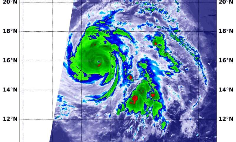
On July 24 at 6:30 a.m. EDT (1030 UTC), the Moderate Resolution Imaging Spectroradiometer or MODIS instrument aboard NASA’s Aqua satellite gathered temperature information about Hurricane Douglas’ cloud tops. Infrared data provides temperature information, and the strongest thunderstorms that reach high into the atmosphere have the coldest cloud top temperatures.
MODIS found the most powerful thunderstorms were in the eyewall, where temperatures were as cold as or colder than minus 70 degrees Fahrenheit (minus 56.6 Celsius). Cloud top temperatures that cold indicate strong storms with the potential to generate heavy rainfall.
Andrew Latto, hurricane specialist at NOAA’s National Hurricane Center noted, “Douglas continues to look impressive in satellite images, with a clear eye and symmetric convection in all quadrants.”
NASA Animates Douglas Through Time
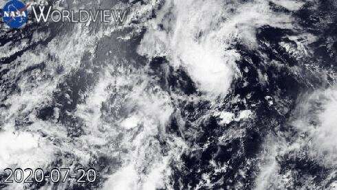
At NASA’s Goddard Space Flight Center in Greenbelt, Md. using the NASA Worldview platform, an animation was created to show Douglas over four days. Using visible imagery from the Visible Infrared Imaging Radiometer Suite (VIIRS) instrument aboard NASA-NOAA’s Suomi NPP satellite, an animation shows the intensification and movement of Hurricane Douglas from July 20 to July 24 in the Eastern Pacific Ocean. Douglas was a Category 4 hurricane on July 24.

Infrared Data Reveals Powerful Storms
On July 24 at 6:30 a.m. EDT (1030 UTC), the Moderate Resolution Imaging Spectroradiometer or MODIS instrument aboard NASA’s Aqua satellite gathered temperature information about Hurricane Douglas’ cloud tops. Infrared data provides temperature information, and the strongest thunderstorms that reach high into the atmosphere have the coldest cloud top temperatures.
MODIS found the most powerful thunderstorms were in the eyewall, where temperatures were as cold as or colder than minus 70 degrees Fahrenheit (minus 56.6 Celsius). Cloud top temperatures that cold indicate strong storms with the potential to generate heavy rainfall.
Andrew Latto, hurricane specialist at NOAA’s National Hurricane Center noted, “Douglas continues to look impressive in satellite images, with a clear eye and symmetric convection in all quadrants.”
Douglas’ Status on Friday, July 24, 2020
At 5 a.m. EDT (0900 UTC), the center of Hurricane Douglas was located near latitude 15.7 degrees north and longitude 140.3 degrees west. That is about 1,010 miles (1,630 km) east-southeast of Hilo, Hawaii.
Douglas is moving toward the west-northwest near 18 mph (30 kph), and this motion is expected to continue for the next few days with a gradual decrease in forward speed and a slight turn toward the west.
Maximum sustained winds are near 130 mph (215 kph) with higher gusts. Douglas is a category 4 hurricane on the Saffir-Simpson Hurricane Wind Scale. Hurricane-force winds extend outward up to 30 miles (45 km) from the center and tropical-storm-force winds extend outward up to 90 miles (150 km). The estimated minimum central pressure is 954 millibars.
Gradual weakening is expected to begin today, July 24, and continue through the weekend.
Citation:
NASA’s tracking Hawaii-bound Major Hurricane Douglas (2020, July 24)
retrieved 24 July 2020
from https://phys.org/news/2020-07-nasa-tracking-hawaii-bound-major-hurricane.html
This document is subject to copyright. Apart from any fair dealing for the purpose of private study or research, no
part may be reproduced without the written permission. The content is provided for information purposes only.
If you want to read more Like this articles, you can visit our Science category.
if you want to watch Movies or Tv Shows go to Dizi.BuradaBiliyorum.Com for forums sites go to Forum.BuradaBiliyorum.Com


