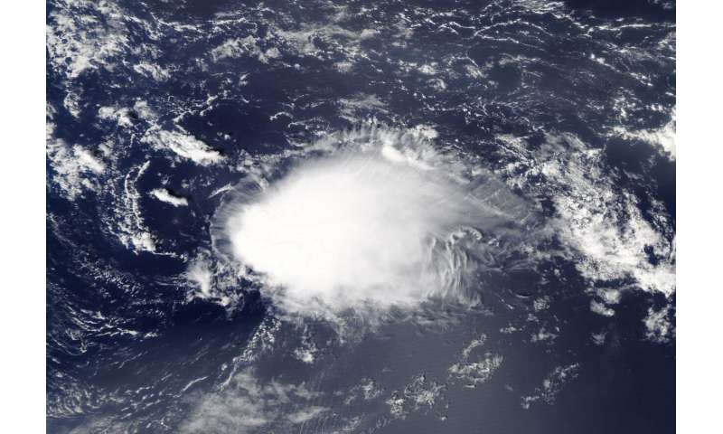
#NASA sees Tropical Depression Rene dissipating
“#NASA sees Tropical Depression Rene dissipating”

NASA’s Aqua satellite captured a visible image of Tropical Depression Rene as it was dissipating in the central North Atlantic Ocean.
The Moderate Resolution Imaging Spectroradiometer or MODIS instrument that flies aboard NASA’s Aqua satellite captured a visible image of Rene on Sept. 15 at 12:30 p.m. EDT. Rene appeared elongated from wind shear (outside winds blowing at different levels of the atmosphere) battering the storm. Over the next couple of hours, visible satellite imagery showed that Rene opened into a trough (elongated area) of low pressure and was no longer a tropical cyclone. Several hours later, Rene dissipated into a remnant low-pressure area.
Satellite imagery was created using NASA’s Worldview product at NASA’s Goddard Space Flight Center in Greenbelt, Md.
Rene’s Curtain Call
At 5 p.m. EDT (2100 UTC) on Sept. 15, NOAA’s National Hurricane Center (NHC) issued the final advisory on Rene, citing that the storm had dissipated. The remnants of Rene were located near latitude 26.9 degrees north and longitude 49.3 degrees west. Rene was located about 1,045 miles (1,685 km) northeast of the Leeward Islands. The remnants were moving toward the west-southwest near 7 mph (11 kph) and this general motion will likely continue for another day or two. Maximum sustained winds were near 30 mph (45 kph) with higher gusts.
The remnants of Rene are expected to move generally southwestward for the next day or two while the associated winds slowly subside.
About NASA’s Worldview and Aqua Satellite
NASA’s Earth Observing System Data and Information System (EOSDIS) Worldview application provides the capability to interactively browse over 700 global, full-resolution satellite imagery layers and then download the underlying data. Many of the available imagery layers are updated within three hours of observation, essentially showing the entire Earth as it looks “right now.”
NASA’s Aqua satellite is one in a fleet of NASA satellites that provide data for hurricane research.
Tropical cyclones/hurricanes are the most powerful weather events on Earth. NASA’s expertise in space and scientific exploration contributes to essential services provided to the American people by other federal agencies, such as hurricane weather forecasting.
Citation:
NASA sees Tropical Depression Rene dissipating (2020, September 15)
retrieved 15 September 2020
from https://phys.org/news/2020-09-nasa-tropical-depression-rene-dissipating.html
This document is subject to copyright. Apart from any fair dealing for the purpose of private study or research, no
part may be reproduced without the written permission. The content is provided for information purposes only.
if you want to watch Movies or Tv Shows go to Dizi.BuradaBiliyorum.Com for forums sites go to Forum.BuradaBiliyorum.Com
If you want to read more Like this articles, you can visit our Science category.


