#NASA-NOAA satellite sees new Tropical Storm Rene drenching Cabo Verde islands
“#NASA-NOAA satellite sees new Tropical Storm Rene drenching Cabo Verde islands”

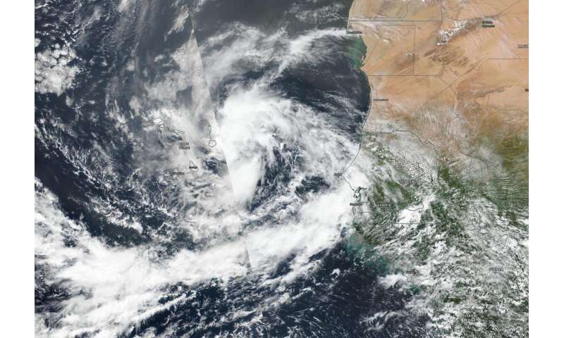
NASA-NOAA’s Suomi NPP satellite provided forecasters with a visible image of the latest tropical cyclone in the North Atlantic hurricane season. Tropical Storm Rene was bringing tropical-storm force winds and rain to the Cabo Verde Islands.
Cabo Verde, also known as Cape Verde, is a country consisting of a chain of islands, located about 385 miles (620 km) off the west coast of Africa.
Tropical Depression 18 developed on Monday, Sept. 7 in the far eastern North Atlantic Ocean, about 250 miles (405 km) east-southeast of the Cabo Verde Islands. By 5 p.m. EDT (2100 UTC) on Sept. 7, the depression strengthened into a tropical storm and was renamed Rene.
On Sept. 8, a Tropical Storm Warning was in effect for the Cabo Verde Islands. The Visible Infrared Imaging Radiometer Suite (VIIRS) instrument aboard Suomi NPP provided a visible image of Rene when it passed overhead. The imagery showed that the tropical storm has a well-defined circulation. However, the banding of thunderstorms around the center has shown no increased organization since Sept. 7.
At 11 a.m. EDT (1500 UTC) on Sept. 8, Tropical Storm Rene was bringing tropical-storm force winds and heavy rain to the western Cabo Verde Islands. The center of Tropical Storm Rene was located near latitude 16.5 degrees north and longitude 26.5 degrees west. Rene was moving toward the west near 16 mph (26 kph), and a motion toward the west to west-northwest is expected over the next two or three days. Maximum sustained winds are near 40 mph (65 kph) with higher gusts. The estimated minimum central pressure is 1001 millibars.
On the forecast track, the center of Rene will move away from the Cabo Verde Islands later today. Little change in strength is expected today, followed by gradual strengthening on Thursday and Friday. Rene is forecast to become a hurricane in a couple of days.
Citation:
NASA-NOAA satellite sees new Tropical Storm Rene drenching Cabo Verde islands (2020, September 8)
retrieved 8 September 2020
from https://phys.org/news/2020-09-nasa-noaa-satellite-tropical-storm-rene.html
This document is subject to copyright. Apart from any fair dealing for the purpose of private study or research, no
part may be reproduced without the written permission. The content is provided for information purposes only.
If you want to read more Like this articles, you can visit our Science category.
if you want to watch Movies or Tv Shows go to Dizi.BuradaBiliyorum.Com for forums sites go to Forum.BuradaBiliyorum.Com

