#Regional climate, kilometer-scale dynamical downscaling over the Tibetan Plateau
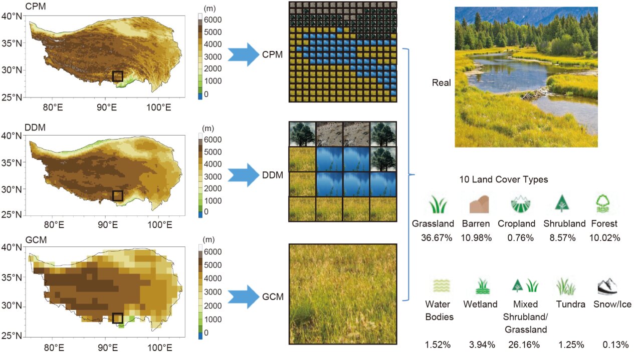
Table of Contents
“Regional climate, kilometer-scale dynamical downscaling over the Tibetan Plateau”
, quarter-degree (DDM in Figure) and global climate model (GCM in Figure) simulate altitude and land cover distribution of the Tibetan Plateau. Credit: Science China Press")
Known as the “Roof of the World,” the Tibetan Plateau is tough to study for meteorological scientists, given its high altitude, steep terrain and harsh natural environments. Limitations and uncertainties of general observation tools spawned model simulations to obtain more comprehensive meteorological information.
However, numerous studies have shown large biases in global climate model simulations over the Tibetan Plateau. To acquire more refined and representative datasets, dynamical downscaling, an important way to obtain high-resolution climate information in the target region, was used.
Influenced by the surface complexity of the Tibetan Plateau, the dynamic downscaling research of the Tibetan Plateau has always been a difficulty in climate modeling. Professor Yanhong Gao is one of the earliest scholars in this field. Her team has been focusing on dynamical downscaling simulations (at about quarter-degree spatial resolution) for about 10 years.
For their study now published in Science China Earth Sciences, they carried out a continuous simulation long-term climate simulations for a period of 33 years from 1979 to 2011, aiming at simulating the changes to the climate and environment.
The study showed that, compared to the simulations at over 100-km resolution, the quarter-degree simulated the observed elevation-dependent warming characteristics more accurately, and better reproduced the different precipitation minus evaporation variability over the western hinterland and southeastern margin of the Tibetan Plateau. The simulations of evapotranspiration and wind speed were also improved to some extent.
Meanwhile, other research teams have also carried out dynamical downscaling simulations over the Tibetan Plateau. For instance, German scientists focused on the precipitation type and the seasonal and inter-annual variability of precipitation in the High Asia glacial region. Results agree with Gao’s viewpoint that orographic precipitation can be simulated more accurately using dynamical downscaling rather than 100-km simulations.
Thanks to supercomputing improvements, the era of kilometer-scale simulation has arrived. Compared with quarter-degree, kilometer-scale dynamical downscaling is able to resolve certain sub-grid convective processes and more accurately describe the influence of the lower boundary (e.g., resolve deep convection processes explicitly, eliminating the need for a deep-convection parameterization scheme and thus avoiding the associated uncertainties).
Gao’s group in kilometer-scale dynamical downscaling research field made the following findings:
(1) They found that kilometer-scale simulations differ little from quarter-degree simulations at altitudinal ranges where observations were available. However, in high-altitude areas over 5,000 meters, there were significant differences between the two simulation scales.
(2) Based on multiple sources of datasets, they evaluated the snow cover simulated at kilometer-scale and quarter-degree grid spacing in high-altitudes areas, with kilometer-scale simulation outperforming the quarter-degree simulation, and both of them reproduced the distribution characteristics of snow cover with altitude more accurately, resulting in a probability density distribution function that was closer to the reference snow product.
(3) Addressing the improvement mechanism of kilometer-scale simulation on daily variation of precipitation, the positive bias of wet convective instability in kilometer-scale simulations was less than that in quarter-degree simulations, which made the timing of the triggering of convection, and its intensity, more consistent with observations; thus, they were able to simulate the diurnal cycle characteristics of precipitation more accurately than previous quarter-degree dynamical downscaling studies.
Dynamical downscaling is an effective way to obtain high-resolution gridded climate information. It can provide a solid support for the study of climate and environmental changes over the Tibetan Plateau and its response to global changes. Along with improvement in the grid spacing and the explicit resolving of deep convective processes, kilometer-scale simulations show certain value-added effects in the triggering time of convection and water vapor transport, heralding a new stage in the evolution of this approach.
Yanhong Gao et al, Regional climate dynamical downscaling over the Tibetan Plateau—From quarter-degree to kilometer-scale, Science China Earth Sciences (2022). DOI: 10.1007/s11430-022-9968-4
Citation:
Regional climate, kilometer-scale dynamical downscaling over the Tibetan Plateau (2022, December 2)
retrieved 2 December 2022
from https://phys.org/news/2022-12-regional-climate-kilometer-scale-dynamical-downscaling.html
This document is subject to copyright. Apart from any fair dealing for the purpose of private study or research, no
part may be reproduced without the written permission. The content is provided for information purposes only.
If you liked the article, do not forget to share it with your friends. Follow us on Google News too, click on the star and choose us from your favorites.
For forums sites go to Forum.BuradaBiliyorum.Com
If you want to read more Like this articles, you can visit our Science category.